

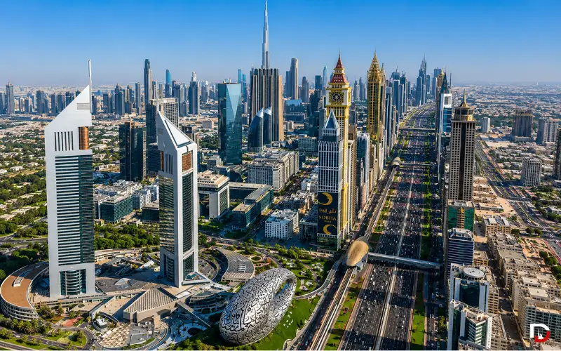
Sheikh Zayed Road is more than just Dubai’s busiest highway. It’s the primary business zone in the city and a section of the E11, which links Dubai’s most popular attractions, such as Burj Khalifa, DIFC, Museum of the Future, and Dubai Marina. Sheikh Zayed Road is an integral part of Dubai, making it a valuable asset for residents, tourists, investors, and those seeking to explore the city. It tells you all about its history, main attractions, transportation routes, nearby communities, and how to make the most of all this iconic road has to offer.
Sheikh Zayed Road at a Glance
| Official Name | E11 / Sheikh Zayed Road (named after Sheikh Zayed bin Sultan Al Nahyan) |
| Type | Dubai’s main highway and central business corridor |
| Total E11 Length | Approximately 558 km, connecting Abu Dhabi to Ras Al Khaimah |
| Dubai Stretch | Roughly 55–60 km through the city, from Al Garhoud to Jebel Ali |
| Lanes | Up to 7–8 lanes in each direction at its widest points |
| Construction Started | 1971, opened in stages through 1980 |
| Managed By | Dubai’s Roads and Transport Authority (RTA) |
| Key Landmarks | Burj Khalifa area, Emirates Towers, Museum of the Future, Dubai World Trade Centre |
| Areas Connected | Downtown Dubai, Business Bay, DIFC, Trade Centre, Al Barsha, Dubai Marina, JLT |
| Metro Access | Dubai Metro Red Line, which carried 294.7 million riders in 2025 |
| Best For | Business travelers, professionals, tourists, and property investors |
What Is Sheikh Zayed Road?
The E11 is Dubai’s road that runs the entire length of the UAE’s west coast, also known as Sheikh Zayed Road. RTA signage is also referred to as “SZR” within Dubai; however, the majority of the residents use the term interchangeably.
It is both a working highway for daily commuters and Dubai’s most visible business and hospitality corridor, with the towers that figure on nearly every postcard of the city.
Visitors from outside the UAE may want to consider not only the main road, but the spine that winds through the SZR, with almost every district worth visiting a direct branch off it, making many Dubai itineraries circle back to the same few exits.
The History of Sheikh Zayed Road
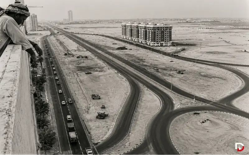
The history of SZR dates back to the early 1970s, when it was nothing more than a desert track linking Dubai to Abu Dhabi. Tire tracks were the only way for drivers to maneuver in the sand, and no lighting or lanes existed.
It started to be constructed in the year of the formation of the UAE, 1971, and was opened progressively over the years until 1980. It was named after Sheikh Zayed bin Sultan Al Nahyan, the UAE’s founding president.
In 1979, the Dubai World Trade Centre was commissioned and was 149m tall, a solitary tower in an unoccupied desert at the time. It was a bold and expensive risk for many to make. This real change started in 1999 and 2005, and the skyline started to rise and rise until the Emirates Towers and later on the Burj Khalifa area near Downtown Dubai.
A Skyline Built in Layers
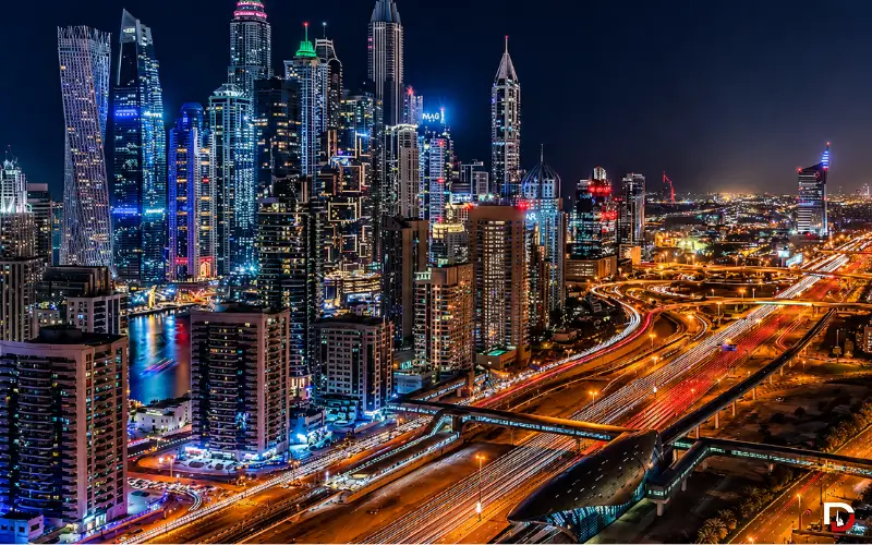
The architectural content of SZR is like a timeline. The 1990s saw the development of older, boxier towers, while the 2000s and 2010s saw a surge in sleeker towers, including Burj Khalifa.
The new additions to the skyline of the City are still growing, and each new structure continues to push the skyline even higher than the previous.
Also Read: Living in Dubai
Where Sheikh Zayed Road Runs
Sheikh Zayed Road is the name of the E11 as it is used in Dubai, and it measures a total of 558 km from Abu Dhabi to the Saudi border, to Ras Al Khaimah on the border with Oman. The route that is commonly referred to as Dubai is approximately 55 to 60 km in length within Dubai.
The road is lined with Al Safa, Al Barsha, Dubai Internet City, Media City, Dubai Marina, and leads up to Jebel Ali from Downtown Dubai and Trade Centre. It is the widest of any street in the town, with as many as seven or eight lanes on each side.
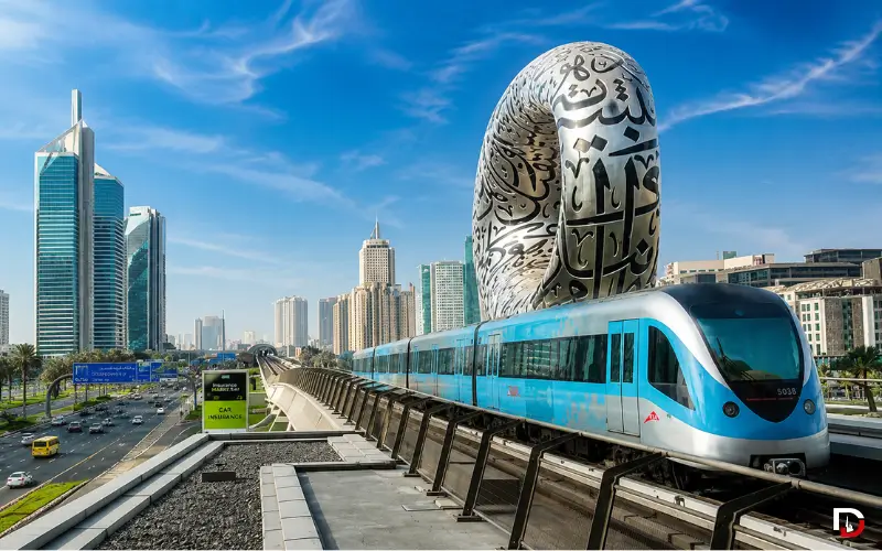
Most of the Dubai Metro Red Line follows the highway, the stations having been designed by the RTA in a shell-like style featuring a nod to the emirate’s pearling past.
Key Landmarks Along Sheikh Zayed Road
No other road in the UAE has as many iconic buildings as this road. You can use this quick reference, which lists the closest Red Line station to each.
| Landmark | Nearest Metro Station | Why It Matters |
| Burj Khalifa / Dubai Mall | Burj Khalifa/Dubai Mall | World’s tallest building; station handled 10.9M riders in 2025 |
| Emirates Towers | Emirates Towers | Twin towers with offices, a hotel, and The Boulevard dining strip |
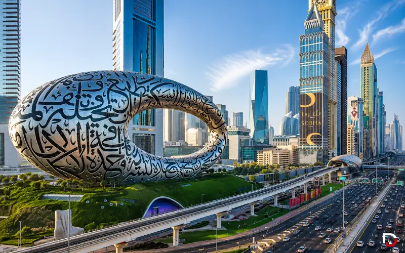
| Museum of the Future | Emirates Towers | Torus-shaped landmark beside Emirates Towers, a top photo spot |
| Dubai World Trade Centre | World Trade Centre | Dubai’s first skyscraper (1979) still hosts GITEX and Gulfood |
| DIFC | Financial Centre | Home to over 8,000 registered firms and 48,000+ professionals |
| Business Bay | Business Bay | Canal-front business and residential towers |
| Dubai Marina | DMCC/Marina area | Waterfront residential and lifestyle district |
| Jumeirah Lake Towers (JLT) | JLT | Mixed-use towers around man-made lakes |
The area that circles Downtown and Trade Centre is often referred to as the postcard Dubai, a wall of glass towers on each side of the highway, which is best seen at golden hour or at night.
Must Read: Sheikh Hamdan Biography
Why This Corridor Matters for Business
SZR is not only a sight to behold; it’s a financial powerhouse in Dubai. In 2025, more than 8,000 businesses are registered at DIFC, and more than 48,000 professionals are working there, as revealed by DIFC’s own results.
The Dubai World Trade Centre is still host to large-scale international events like GITEX and Gulfood all year round to attract international business traffic to the corridor.
Sheikh Zayed Road vs Other Major Dubai Roads
One can easily get Dubai’s other highways confused with SZR. Further inland is Al Khail Road (E44), which is a quicker route, particularly during rush hour, and Mohammed Bin Zayed Road (E311) is an outer ring for longer cross-city trips.
| Road | Best For | Character |
| Sheikh Zayed Road (E11) | Landmarks, business districts, and hotels | Skyline corridor; heaviest traffic, most direct to Downtown/DIFC |
| Al Khail Road (E44) | Bypassing SZR congestion | Faster inland route with fewer landmark exits |
| Mohammed Bin Zayed Rd (E311) | Long inter-emirate journeys | Outer ring road, further from the coast, built for speed and volume |
Dubai’s showcase bypass is SZR. That’s why it’s cherished despite being a slower option compared to other roads being used for through traffic.
Neighborhoods and Communities Along SZR
When you live or work along Sheikh Zayed Road, you’re presented with a variety of different communities, each more unique in its character and price point.
| Community | Rent vs SZR Average | Metro Access | Best For |
| Downtown Dubai | Highest | Direct — Burj Khalifa/Dubai Mall station | Landmark views, walkability |
| DIFC / Trade Centre | High | Direct — Financial Centre & Emirates Towers | Finance and legal professionals |
| Business Bay | Mid-to-high | Direct — Business Bay station | Canal views, newer towers |
| Al Barsha / Internet City | Mid | Direct — several Red Line stops | Tech and media professionals |
| Dubai Marina / JLT | Mid | Direct — Marina/JLT stations | Younger residents, waterfront living |
Downtown Dubai and Business Bay are closest to Burj Khalifa and the canal, perfect for working people looking to be within walking distance of the sights. The financial and corporate center is the DIFC and Trade Centre, which is a mix of office towers, hotels, and high-end apartments.
Dubai Marina and JLT open up into waterfront living with a younger crowd and more affordable rents further along, and are also directly on the Red Line (see our Dubai Marina Guide for more details on this section in particular).
Getting Around: Dubai Metro and RTA Transport
Dubai’s transportation system makes it easy to get to and around SZR. According to RTA data, Dubai Metro travelers used the Red and Green lines to move 294.7 million passengers in 2025, an increase of 7% compared to 2024, with Burj Khalifa/Dubai Mall station alone seeing 10.9 million passengers.
The Red Line runs close to all the main points, from Trade Centre to Emirates Towers, to Mall of the Emirates, and Dubai Marina.
RTA buses and feeder services cover the gaps between stations, and taxis, Careem, and Uber are common after hours or when slightly away from the metro line. In 2025, the average number of public transport users per day in Dubai was 2.2 million.
Living on Sheikh Zayed Road: Pros and Cons
To locals, SZR is a trade-off that is common to anyone who has ever lived along a major city artery: great connectivity for higher rents, and more road noise.
| Pros | Cons |
| Direct Metro Red Line access to almost everywhere in Dubai | Rents run higher than outer communities |
| Walking distance to malls, hotels, and dining | Road noise on lower floors facing the highway |
| Fast commute to DIFC, Downtown, and Business Bay | Street parking is scarce; rely on building or mall parking |
| Landmark views (Burj Khalifa, Museum of the Future) | Not pedestrian-friendly at street level |
Real Estate and Investment on Sheikh Zayed Road
The property along SZR is in the high-end of the Dubai market. Towers that are pointed towards the highway or have a commanding view of the Burj Khalifa area are more likely to have a higher rent.
As with all Dubai property purchases, buyers should verify the ownership and registration information with the Dubai Land Department (DLD) before making a purchase. Strong interest has remained in the corridor with a regular flow of launches in proximity to the Trade Centre and Downtown.
Established towers continue to see healthy rental demand from DIFC’s finance, legal, and consulting professionals, a workforce that grew 9% year-on-year to over 48,000 people in 2025.
If you are moving into a rental for the first time, service charges on SZR-facing towers can also be higher than they are on outer towers, and users should be aware of this as well as the base rent — it is the amenities and views that come with these buildings.
Dining, Hotels, and Lifestyle on SZR
Sheikh Zayed Road hotels have more 5-star properties per kilometer than anywhere else, all the way from the Downtown end near Burj Khalifa to the Trade Centre roundabout.
The Emirates Towers Boulevard is home to a strip of popular restaurants, which serve the business community during working hours and a more vibrant nightlife at night. Options proliferate with Souk Al Bahar and the Dubai Mall downtown, with views of the Burj Khalifa fountains.
Practical Visitor Tips
- Best time to visit landmarks: early morning and after 4 PM to avoid peak heat or Downtown crowds.
- If you are only visiting the Downtown/DIFC/Trade Centre area, use Metro instead of a rental car.
- Pre-book mall or hotel parking for big events at Dubai World Trade Centre, like GITEX or Gulfood.
- Never cross at street level (only in pedestrian crossings at metro stations near SZR)
- Visit Dubai’s event calendar to avoid traffic and hotel price changes in the corridor during exhibitions.
Common Mistakes First-Time Visitors Make
- If SZR is walkable between the markers, it is highway-scale distances.
- Driving during peak hours (7–9 AM and 5–7 PM) without checking traffic first.
- Reserving a hotel “on Sheikh Zayed Road” but not knowing which part of the road (Downtown, Trade Centre, and Marina are all on SZR, but feel very different).
Best Photo Spots
- For the straight-on view of the Burj Khalifa skyline, the Dubai Frame or Downtown pedestrian bridges are good options.
- The walkway of the Emirates Towers Boulevard towards the Museum of the Future.
- Sunset over Business Bay Bridge, with the canal visible in the foreground.
Quick Travel Tips
- Download the RTA Dubai or S’hail app before travelling for real-time Metro schedules and route planning.
- If you are traveling the Metro more than once, keep a NOL on hand — this is preferable to paying individual tickets each trip.
- When you compare hotels, see what SZR cluster it’s located in first: Downtown, Trade Centre, and Marina all have the SZR name, but vary in price and vibes.
The Future of Sheikh Zayed Road
There are no indications that development on SZR is slowing down. The growing density of the skyline has recently seen several residential and mixed-use towers take shape near the Trade Centre and the Downtown stretch.
RTA’s long-term vision also involves the development of more dedicated lanes for buses and taxis as part of Dubai’s efforts to promote sustainable mobility, as well as the further expansion of the Metro network, in line with the Dubai 2040 Urban Plan.
Final Thoughts
Sheikh Zayed Road is not just Dubai’s primary highway; it’s the place where the city’s history, business aspirations, and daily life converge. It has developed from a desert track to an eight-lane superhighway, just as Dubai itself has.
Ideal for professionals seeking easy access, investors keen on the prospects of the DIFC, and tourists who appreciate easy access to most major attractions within a short metro ride.
From relocating to investing, or just taking a trip to Dubai, the one thing you want to understand is this: one road, and Dubai’s layout begins to make sense. Save this guide before you make your next journey through the corridor; new towers and transit changes are continually added to SZR.
Also Read: Al Awir Immigration Office Dubai
Frequently Asked Questions
1. What does SZR stand for?
Sheikh Zayed Road (SZR) is the key road in Dubai, designated E11.
2. Who is Sheikh Zayed Road named after?
It was named after Sheikh Zayed bin Sultan Al Nahyan, the UAE’s founding president.
3. How long is Sheikh Zayed Road?
The total length of E11 is approximately 558 km, and approximately 55-60 km is within Dubai city.
4. Which metro station is closest to Burj Khalifa?
The Red Line’s Burj Khalifa/Dubai Mall station is right next to Downtown Dubai.
5. Is Sheikh Zayed Road good for tourists?
Yes, the majority of the major attractions are within a short metro ride or drive of each other.
6. Is Sheikh Zayed Road walkable?
Not directly, so use the metro stations or pedestrian bridges.
7. Is parking difficult on Sheikh Zayed Road?
Street parking is restricted, and most visitors park in the malls, hotels, or building parking lots.
8. Is living on Sheikh Zayed Road expensive?
Yes, rents are higher than the average in Dubai, particularly Downtown and DIFC towers.
9. Is the Dubai Metro available along SZR?
Yes, the Red Line is parallel to Sheikh Zayed Road and its stations are located at all key locations.
10. What are the major landmarks on Sheikh Zayed Road?
The most famous include Burj Khalifa, Emirates Towers, Museum of the Future, and Dubai World Trade Centre.
11. How far is Sheikh Zayed Road from Dubai Airport?
SZR starts in Dubai city center, which is approximately a 15–20-minute drive from Dubai International Airport.
12. Is Sheikh Zayed Road busy with traffic?
Yes, these are usually the 7–9 AM and 5–7 PM of the weekday.